ROCORI Trail Connects Three Cities After Years of Collaboration
By Heather Rule

The ROCORI Trail project didn’t start when the asphalt was paved. It didn’t start when grants and other funding came through. It started 18 years ago “with some trail-enthusiastic residents who got together at the café and just had a conversation,” said Kevin Mooney, Richmond parks and recreation director, who has been with the department for 19 years.
The residents brought the idea for a trail to leaders of the three cities that it would connect — Rockville, Cold Spring, and Richmond, also known as ROCORI. From there, the ROCORI Trail Construction Board (RTCB) was born, the first funding came through, and they were off and running.
“Or … not running; this process has taken us forever,” Mooney said, with a chuckle. “We were off and crawling at a very slow pace.”
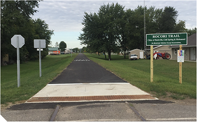
Unsurprisingly, a project of this magnitude does take a lot of time. The ROCORI Trail is about 10 miles of asphalt and a multipurpose trail. Going from west to east, Richmond is the first city along the route, with Cold Spring in the middle about 5 miles away, and Rockville approximately another 5 miles east. The trail is wheelchair accessible and can be used for biking, inline skating or walking, and for snowmobiles in the winter.
The desire for a new route
Now, after nearly two decades in the making, the cities are finally celebrating the project’s completion this year.
Before the trail, State Highway 23 (a two-lane highway that has since expanded to four lanes) was the only route connecting the three cities.
There was no way to get from one community to the other without a vehicle, and there was a desire for an alternative route for people to walk or bike, Mooney said.
The new route offers other benefits as well. Between Cold Spring and Rockville, the trail goes along the Sauk River providing some scenic views.
“A lot of good views all along. A lot of rolling hills,” said Doug Schmitz, Cold Spring City Council member and a RTCB board member since the beginning.
RTCB leads the way

Once the viability of a trail project became clear, the cities formed a joint powers agreement. Since about 2006, the six-member RTCB met monthly at Rockville City Hall. The board includes two voting members (city staff, council, mayors, or residents) representing each city. The board’s chair rotates between the cities annually, with that town’s city administrator acting as executive director for the year. Mooney, who’s been on the RTCB since the start, is this year’s chair.
One of the board’s earliest tasks, and a big one, was dealing with a slow but active railroad in Paynesville and Rockville. The board worked with BNSF Railway Company as the railroad opted to abandon the tracks and sell a 100-foot corridor west of Rockville to the RTCB.
“That was how the project actually started, was getting the purchase of that land,” Schmitz said.
Keeping it on track
With the corridor purchased, the ROCORI Trail project could really take shape. In 2009, the first, 1-mile stretch of trail was completed in Rockville. Around 2012, a 3-mile section was completed between Cold Spring and Richmond.
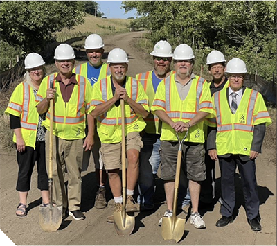
Now, trail travelers could start west in Roscoe, another neighboring town, and go 17 miles all the way to Rockville via two trail systems that are connected, including the Glacial Lakes State Trail. The final phase of the trail started in fall 2022 and finished around Memorial Day 2023.
“It takes a long time to get things accomplished,” said Duane Willenbring, Rockville mayor and an original voting member of the RTCB. “How did the ROCORI trail come to be? That was due diligence, a lot of research, selecting the right people, and then have patience.”
As Willenbring pointed out, the three cities have “a long history of working collectively and primarily” due to the consolidation of the ROCORI School District.
Collaboration was key
With three different councils, three mayors, three different mindsets for each city, Mooney said, “It’s amazing that this group has hung together for 19 years with its main focus being connectivity … connecting our communities with something healthy like recreation.”
Bringing the cities together via the RTCB involved a lot of cooperation, collaboration, and compromise to see all phases of the project come to fruition. Each city representative makes decisions for their respective community but also for the two other cities, so everything involved a lot of understanding and compromise to reach the common goal of the three-city connection, Mooney said.
Collaboration was a word that Schmitz used, too, to describe the good working relationship between the three cities. He also believes it was that common goal that helped keep things on track.
“That’s the journey, and it’s been very fruitful,” Willenbring said. “It’s been trying at times. But the good outweighed the bad, hundredfold.”
Funding the project
In total, the trail project cost about $7 million, which includes buying the rail corridor from BNSF for about $1.8 million and then trail construction, engineering, and remaining costs coming in at a little more than $5 million, according to Mooney. The RTCB also worked with Stearns County as their fiscal agent, with a county supervisor at each of the trail meetings.
The money came from multiple areas at the federal, state, and local levels. A federal transportation alternative program helped fund parts of all three project phases. They also received Legislative- Citizen Commission on Minnesota Resources (LCCMR) money, directed through a bonding bill. Stearns County helped fund the first phase, and all three cities contributed funds as well, according to Mooney.
“But to tell you the truth, we managed to do this without really impacting our community’s tax base too much,” Mooney said. “We shook every tree we could.”
Residents and tourists hit the trail
Once the trail was operational, Mooney, who’s lived in the area for 30 years, said he noticed a transformation in Richmond. He saw more people cycling, and he heard from the local hardware store owner that the business sold and fixed more bicycles than in the past. Richmond also constructed a trail pavilion with a parking lot and bike racks, both of which can be full on a Saturday morning, Mooney said.
Seeing all the walking, roller blading, recreation, and exercise community members get from using the trail is phenomenal, he said. Once the connection with Cold Spring was complete, Mooney saw those residents in Richmond more often, too.
“I think it’s made our community much more active,” he said. “Just out and about and getting some exercise.”
The connectivity of the trail is the most important piece for all three cities. Although the RTCB envisioned the trail would be used by many, seeing the actual number of people on the trail is still pleasantly surprising to Schmitz.
“I didn’t think it would be used as much as it is,” Schmitz said. “Nonstop, you see people walking, roller blading, biking. So, I think just seeing the people out there being able to enjoy this is great feedback for me.”
With only 5 miles between the cities via the trail, the big benefit is that residents can head to these other cities without getting on the highway. Schmitz sees community members using the trail to bike and stop at Cold Spring offerings such as the splash pad, bakery, or ice cream shop. A lot more people on bikes are “coming and stopping in town now,” Schmitz said.
On the horizon
In celebration of the trail’s completion, the communities planned a grand opening celebration on June 17, complete with pedal pubs from the Twin Cities. Going forward, the plan is to turn the ROCORI Trail over to the Minnesota DNR to manage and maintain so it will not be the responsibility of the three cities, according to Schmitz.
The trail checks the boxes of safety, recreation, and community connection. Willenbring said he doesn’t know what the full impact of the trail will be, “but hopefully that ripple effect of the tourism it might attract should be beneficial to a lot of us.”
Anyone can hop on their bicycle to go see a movie in Cold Spring, then pedal their way along the trail to Richmond and stop for an ice cream cone, Mooney said, as another example of how the public can use the trail to get around.
“The response that we’ve had on this trail has been phenomenal,” Mooney said. “Any time you drive by, you see people moving in a different way than starting up a combustible engine.
“It’s just such a great amenity for our cities and our school district.”
Heather Rule is a freelance writer.

